
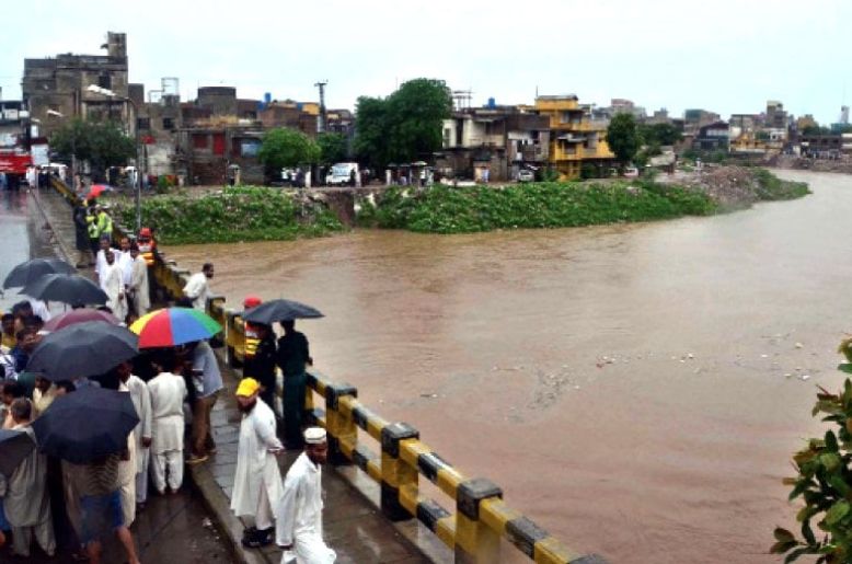
It is not correct to view Lai Nullah as merely an ordinary urban drain. It is, in fact, a natural rainwater drainage system whose entire catchment extends from the Margalla Hills to the Swan River in Rawalpindi. Today, human mismanagement has severely disrupted the twin cities’ natural rainwater drainage system. In the beginning, the Federal Capital area was limited, but over time it gradually expanded. Today, its boundaries extend from Rawat on one side to Fateh Jang on the other.
Over the last twenty years, a large number of housing societies have been established, while the Capital Development Authority (CDA) has also developed several new sectors. Many sectors and housing societies have been developed around the Lai Nullah, stretching from Islamabad to Rawalpindi, without adequate planning or consideration for the natural drainage system. At several points, the width of the Lai Nullah and its associated drainage channels has been deliberately reduced or altered without any proper plan or assessment of the consequences.
Last week, residents of both Rawalpindi and Islamabad witnessed one of the worst episodes of urban flooding in recent years. Several major highways and roads turned into rivers, trapping commuters in their vehicles and bringing traffic to a standstill. This was an ordinary monsoon downpour, yet it was enough, once again, to bring Pakistan’s capital region to its knees. The question being raised today is: why did this happen?
The answer lies largely in human mismanagement. The continued cutting, narrowing and obstruction of the natural rainwater drainage system, particularly the Lai Nullah and its connected channels, will make the situation even worse in the coming years if this practice continues. Another major reason is the illegal establishment of encroachments along the banks of the Lai Nullah, which further restrict the natural flow of rainwater. To understand the seriousness of the problem, it is important to understand the natural drainage system and history of the Lai Nullah.
Lai Nullah and its catchment
Lai Nullah is a natural, rain-fed stormwater channel that collects water from the Margalla Hills and flows from Islamabad towards Rawalpindi, eventually emptying into the Swan River. During the monsoon season, heavy rainfall across its catchment area can cause a sudden and dangerous increase in the flow of water in the Lai Nullah.
The entire catchment area of the Lai Nullah is approximately 234.8 square kilometres, covering parts of both Islamabad and Rawalpindi. Recent government planning documents have also placed its catchment area at approximately 234.9 square kilometres.
Several major stormwater drains originate in the Margalla Hills of Islamabad, including Saidpur Kas, Tanwali Kas and Badrawali Kas. These drains carry rainwater from Islamabad and join the main Lai Nullah near Katarian Bridge. After Katarian Bridge, the Lai Nullah enters the boundaries of Rawalpindi, where it is joined by several other drainage channels, including Niki Lai, Pir Wadhai Kas and Dhok Ratta Nala.
2001 Lai Nullah flood: Disaster that still haunts Twin cities
July 23, 2001, is considered one of the most devastating flood events in the history of the Lai Nullah. On that day, approximately 620 millimetres of rain were recorded in Islamabad within just 10 hours. As a result of this extraordinary rainfall, the water level in the Lai Nullah and its connecting drains rose extremely rapidly, causing widespread destruction in the low-lying areas of Rawalpindi.
The disaster reportedly killed 74 people and affected approximately 400,000 people, while around 3,000 houses were completely or partially destroyed. Various government and technical reports have estimated the resulting damage to property, infrastructure and other assets in billions of rupees.
When cities illegally expand, natural drains pay the price
The problem of the Lai Nullah is not simply a matter of water volume. It is closely linked to the entire catchment area, rapid urban expansion, encroachments and the increasing population of low-lying areas. Heavy rainfall in the Margalla Hills can drain towards the Lai Nullah within a relatively short period. At the same time, densely populated and low-lying areas of Rawalpindi have developed along and around the drainage channel.
As a result, during heavy rainfall, the water level in the Lai Nullah can rise very quickly. In some locations, prolonged rainfall is not even necessary to trigger serious flooding. Research studies have also identified several low-lying areas of Rawalpindi as particularly vulnerable to Lai Nullah flooding.
It is therefore misleading to treat the Lai Nullah as merely an ordinary urban drain. It is a natural rainwater drainage system, and its catchment extends from the Margalla Hills in Islamabad to the Swan River in Rawalpindi.
The various drains, natural rainwater channels and urban drainage systems connected to the Lai Nullah are all part of an interconnected network. This is why the impact of heavy rainfall in the Islamabad catchment can be felt in the low-lying areas of Rawalpindi after a certain period of time.
Any attempt to understand flooding in the twin cities must therefore begin with an understanding of the entire Lai Nullah drainage system. Narrowing the channel, blocking natural waterways, allowing encroachments along its banks and permitting unplanned urban development within its catchment can only increase the risk of catastrophic flooding.
The recent flooding should therefore be treated not merely as the result of heavy rainfall, but as a warning about the consequences of decades of poor urban planning and inadequate management of the region’s natural drainage system. If this practice of narrowing, obstructing and encroaching upon the Lai Nullah and its connected drainage channels continues, the consequences in the coming years could be far more severe.
Understanding the Lai Nullah is, in reality, understanding the entire urban flood system of Islamabad and Rawalpindi. Protecting its natural flow and preserving its catchment is not simply an environmental responsibility; it is essential for the safety and future of the twin cities.
